Project: G3W-SUITE
Changelog for version: 3.8
Release date: 17 June 2024
G3W-SUITE 3.8 is characterized by refactoring work relating to the management aspects of the tools, the visualization of tabular data and the aspects of coherence in saving the changes made in editing in the case of 1:N cascade relations.
Furthermore, the version features these important new features:
the possibility to hide layers from the TOC
the possibility for the logged user to create/save customized themes as in QGIS
export the map also in SVG and GeoPDF format by defining custom scale and DPI values
multigeometric layer editing management
download attribute of a layer in PDF format
G3W-SUITE is an open source project and if you are able to, consider supporting our work through donations or contributions to the code documentation, web site and so on. Among the main funder of this version we remember:
G3W-SUITE 3.8 is compatible with the new 3.34 LTR of QGIS
Take advantage of all the news related to the preparation of QGIS projects with the new LTR version

The list of Cartographic Groups can be filtered based on:
The options of this last filter vary based on the type of logged in user
It is now possible to hide one or more layers from the TOC, still continuing to view it on the map or make it available for searches, aspects related to editing and other functions
It is possible to allow the download, in PDF format, of the attributes of the geometries displayed following queries or searches.
There are limitations related to the structure of the customized form
G3W-SUITE exposes the service managed by QGIS Server
For more information:
https://docs.qgis.org/3.34/en/docs/server_manual/services/ogcapif.html

Logged users can create their own themes (combination of on/off layers) and save them for future use as in QGIS.
The styles associated with individual layers are also managed within themes.
The editing flow relating to the management of 1:N cascade relations has been completely revisited to ensure greater robustness and manage the various possible cases.
In the case of 1:N cascading vector-type relations, a new method (copy features from another layer) has been added to the manual creation of new children features of the relation.
As in QGIS, the AddPart tool also allows the creation/association of geometry to records, of geometric layers, which do not have them
It is possible to easily manage multigeometric layers by associating different types of geometries with the individual records of the layer
In the case of an editable layer, it is possible to start editing the individual features directly from the attribute table.
It is also possible to easily switch from displaying data in a table to that in an extended form and vice versa.
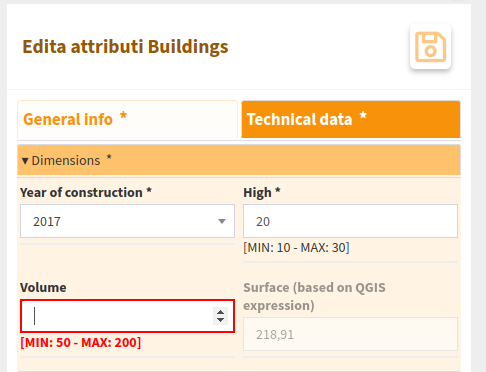
The recognition of field types (integer, double, text…) allows you to avoid entering incorrect values on the various fields in order to avoid errors when saving
With this version it is also possible to export prints to JPG, SVG and GeoPDF
The user can manually define the scale and DPI values for the the print outputs
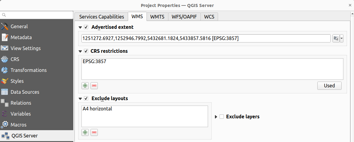
Eredited from QGIS projects
If on the QGIS project I exclude a print layout from those available in the WMS service, this is excluded also from the WebGis service
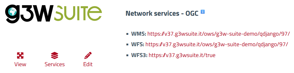
For each published WebGis service, the associated OGC services can be consulted
WFS queries (QueryByBox, QueryByPolyon and QueryByDrawPolygon) are extended to layers deriving from embedded projects